|
Do you want to know...
|
1. What is ENSO
2. What's the difference between EP El Niño and CP El Niño 3. What occurs when in warm phase and cool phase of ENSO |
1. What is ENSOENSO ='El Niño–Southern Oscillation' 1) El Niño
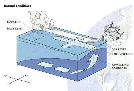
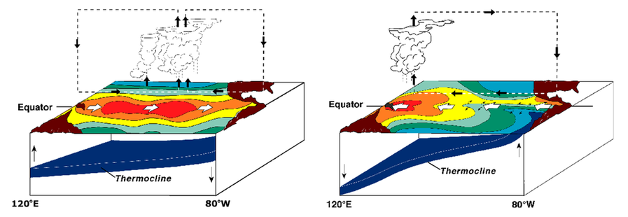
Under normal conditions
Easterly trade winds blow from east to west along the equator and push warm surface water toward the western Pacific. The atmosphere above the ocean heats up, creating favorable conditions for convection and precipitation and some of the heaviest rainfall in areas surrounding Indonesia and other western Pacific islands. As the easterly trade winds push warm surface water against the western boundary of the Pacific Ocean, colder, nutrient-rich water is upwelled from below along the coast of South America to replace it. Furthermore, as the layer of warm water moves toward the west, the layer dividing warm surface water and cold deep water - known as the thermocline - is raised. Coastal upwelling of nutrient-rich cold water from the deep ocean facilitates the production of plankton, which helps fishes and other animals to thrive. In the upper levels of the atmosphere, the winds blow from west to east to complete what is known as the Southern Oscillation. When air pressure rises in the east Pacific, the opposite occurs in the west. Also, because trade winds push water westward, sea level on the western Pacific is higher than the east. |
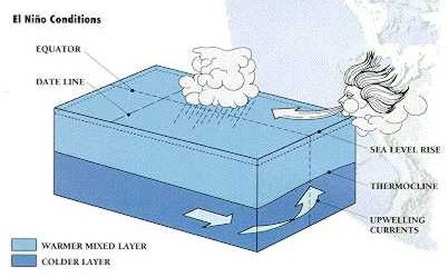
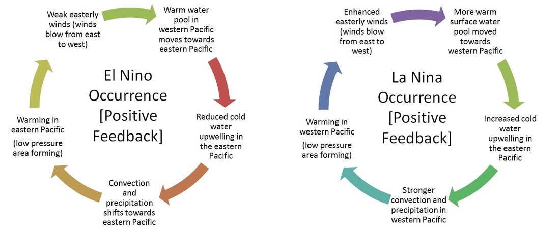
An El Nino event begins when the easterly winds begin to weaken and the warm pool of water moves back towards the east and South American continent, while upwelling of cold water along the South American coast decreases. The Pacific Ocean is now warmer on its eastern side and coastal upwelling along the western coast of South America is reduced, resulting in a lack of nutrient-rich water for plankton production. Sea level drops in the west and rises in the east as warm surface water flows along the equator.
As the warm water is displaced, convection and precipitation that occurred previously in the western Pacific shifts with the warm pool towards the central and eastern Pacific, Thus the major rain zone shifts eastwards as well, causing a prolonged dry period in Indonesia, the Philippines and northern Australia while resulting in increased rainfall over tropical South America. The behaviour of the ocean and atmosphere reinforce each other until a full-scale El Nino is underway.
As the warm water is displaced, convection and precipitation that occurred previously in the western Pacific shifts with the warm pool towards the central and eastern Pacific, Thus the major rain zone shifts eastwards as well, causing a prolonged dry period in Indonesia, the Philippines and northern Australia while resulting in increased rainfall over tropical South America. The behaviour of the ocean and atmosphere reinforce each other until a full-scale El Nino is underway.
2) Southern Oscillation
The Southern Oscillation is the atmospheric component of El Niño. This component is an oscillation in surface air pressure between the tropical eastern and the western Pacific Ocean waters. The strength of the Southern Oscillation is measured by the Southern Oscillation Index (SOI).
The SOI is computed from fluctuations in the surface air pressure difference between Tahiti and Darwin,[i] Australia El Niño episodes are associated with negative values of the SOI, meaning there is below normal pressure over Tahiti and above normal pressure of Darwin.
Walker circulation
During non-El Niño conditions, the Walker circulation is seen at the surface as easterly trade winds that move water and air warmed by the sun toward the west. This also creates ocean upwelling off the coasts of Peru and Ecuador and brings nutrient-rich cold water to the surface, increasing fishing stocks. The western side of the equatorial Pacific is characterized by warm, wet, low-pressure weather as the collected moisture is dumped in the form of typhoons and thunderstorms. The ocean is some 60 cm (24 in) higher in the western Pacific as the result of this motion.[ii][iii][iv][v]
2. Difference between
EP El Niño and CP El Niño
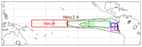 Map showing Niño3.4 and other index regions
The traditional Niño, also called Eastern Pacific (EP) El Niño, involves temperature anomalies in the Eastern Pacific. However, in the last two decades, nontraditional El Niños were observed, in which the usual place of the temperature anomaly (Niño 1 and 2) is not affected, but an anomaly arises in the central Pacific (Niño 3.4). The phenomenon is called Central Pacific (CP) El Niño,"dateline" El Niño (because the anomaly arises near the dateline), or El Niño "Modoki" (Modoki is Japanese for "similar, but different"). There are flavors of ENSO additional to EP and CP types and some scientists argue that ENSO exists as a continuum often with hybrid types.
The effects of the CP El Niño are different from those of the traditional EP El Niño—e.g., the new El Niño leads to more hurricanes more frequently making landfall in the Atlantic.
The recent discovery of El Niño Modoki has some scientists believing it to be linked to global warming. However, comprehensive satellite data go back only to 1979. More research must be done to find the correlation and study past El Niño episodes. More generally, there is no scientific consensus on how/if climate change may affect ENSO.
There is also a scientific debate on the very existence of this "new" ENSO. Indeed, a number of studies dispute the reality of this statistical distinction or its increasing occurrence, or both, either arguing the reliable record is too short to detect such a distinction, finding no distinction or trend using other statistical approaches, or that other types should be distinguished, such as standard and extreme El Niños. Following the asymmetric nature of the warm and cold phases of ENSO, a study could not identify such distinctions for La Niña, both in observations and in the climate models.
The first recorded El Niño that originated in the central Pacific and moved toward the east was in 1986.
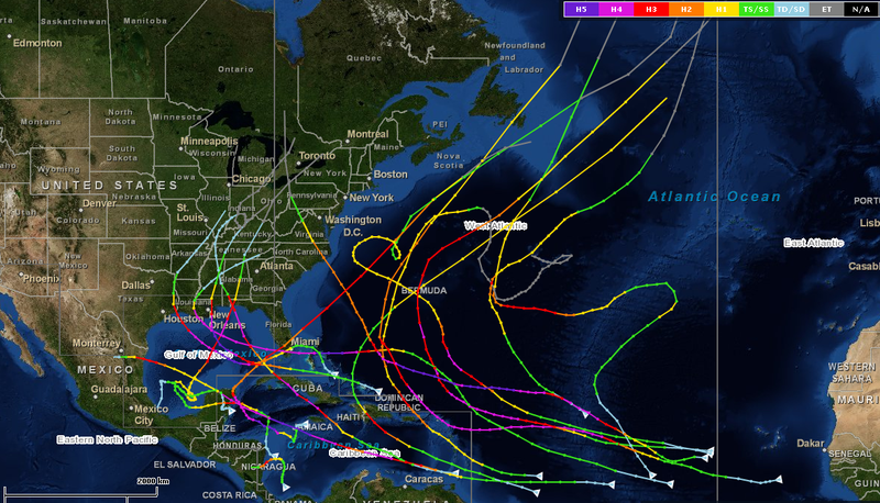
Map of Atlantic major hurricanes during post-"Modoki" seasons, including 1987, 1992, 1995, 2003 and 2005
3. What occurs when in warm phase
and cool phase of ENSO
|
The Warm phase of ENSO is El Niño!
When El Niño occurs : Warm water pool approaches the South American coast. The absence of cold upwelling increases warming. |
The Cold phase of ENSO is La Niña!
When La Niña occurs : Warm water is farther west than usual |
Effects of ENSO warm phase (El Niño)
South America
Because El Niño's warm pool feeds thunderstorms above, it creates increased rainfall across the east-central and eastern Pacific Ocean, including several portions of the South American west coast. The effects of El Niño in South America are direct and stronger than in North America. An El Niño is associated with warm and very wet weather months in April–October along the coasts of northern Peru and Ecuador, causing major flooding whenever the event is strong or extreme. The effects during the months of February, March, and April may become critical.
Along the west coast of South America, El Niño reduces the upwelling of cold, nutrient-rich water that sustains large fish populations, which in turn sustain abundant sea birds, whose droppings support the fertilizer industry. The reduction in upwelling leads to fish kills off the shore of Peru. The local fishing industry along the affected coastline can suffer during long-lasting El Niño events. The world's largest fishery collapsed due to overfishing during the 1972 El Niño Peruvian anchoveta reduction. Shifting locations and types of fish due to changing conditions provide challenges for fishing industries. Peruvian sardines have moved during El Niño events to Chilean areas.
North America
Winters, during the El Niño effect, are warmer and drier than average in the Northwest, northern Midwest, and northern Mideast United States, so those regions experience reduced snowfalls. Meanwhile, significantly wetter winters are present in northwest Mexico and the southwest United States, including central and southern California, while both cooler and wetter than average winters in northeast Mexico and the southeast United States (including the Tidewater region of Virginia) occur during the El Niño phase of the oscillation.[vi][vii]
Tropical cyclones
Most tropical cyclones form on the side of the subtropical ridge closer to the equator, then move poleward past the ridge axis before recurving into the main belt of the Westerlies. When the subtropical ridge position shifts due to El Niño, so will the preferred tropical cyclone tracks. Areas west of Japan and Korea tend to experience much fewer September–November tropical cyclone impacts during El Niño and neutral years. During El Niño years, the break in the subtropical ridge tends to lie near 130°E, which would favor the Japanese archipelago.
During El Niño years, Guam's chance of a tropical cyclone impact is one-third of the long-term average. The tropical Atlantic ocean experiences depressed activity due to increased vertical wind shear across the region during El Niño years. On the flip side, however, the tropical Pacific Ocean east of the dateline has above-normal activity during El Niño years due to water temperatures well above average and decreased windshear. Most of the recorded East Pacific category 5 hurricanes occur during El Niño years in clusters.
Effects of ENSO's cool phase (La Niña)
Africa
La Niña results in wetter-than-normal conditions in Southern Africa from December to February, and drier-than-normal conditions over equatorial East Africa over the same period.
Asia
During La Niña years, the formation of tropical cyclones, along with the subtropical ridge position, shifts westward across the western Pacific ocean, which increases the landfall threat to China. In March 2008, La Niña caused a drop in sea surface temperatures over Southeast Asia by 2°C. It also caused heavy rains over Malaysia, the Philippines, and Indonesia.
During La Niña years, the formation of tropical cyclones, along with the subtropical ridge position, shifts westward across the western Pacific ocean, which increases the landfall threat to China. In March 2008, La Niña caused a drop in sea surface temperatures over Southeast Asia by 2°C. It also caused heavy rains over Malaysia, the Philippines, and Indonesia.
South America
During a time of La Niña, drought plagues the coastal regions of Peru and Chile. From December to February, northern Brazil is wetter than normal.
During a time of La Niña, drought plagues the coastal regions of Peru and Chile. From December to February, northern Brazil is wetter than normal.
North America
La Niña causes mostly the opposite effects of El Niño, above-average precipitation across the northern Midwest, the northern Rockies, Northern alifornia, and the Pacific Northwest's southern and eastern regions. Meanwhile, precipitation in the southwestern and southeastern states is below average. This also allows way above average hurricanes in the Atlantic and less in the Pacific.
La Niña causes mostly the opposite effects of El Niño, above-average precipitation across the northern Midwest, the northern Rockies, Northern alifornia, and the Pacific Northwest's southern and eastern regions. Meanwhile, precipitation in the southwestern and southeastern states is below average. This also allows way above average hurricanes in the Atlantic and less in the Pacific.